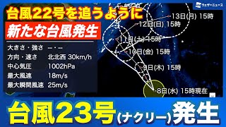
It may later shift its path eastward, but the extent of its northward movement remains uncertain. Authorities are urging the public to stay alert for updates on the typhoon’s course.
As of the afternoon of October 8th, Typhoon No. 23 was located east of the Philippines with a central pressure of 1002 hectopascals, maximum sustained winds of 18 meters per second, and maximum gusts reaching 25 meters per second.
The storm is projected to move northward and approach the vicinity of Amami around October 11th before veering northeast. It is then forecast to track eastward, passing south of Japan’s main islands. Unlike Typhoon No. 22 (Halong), Nakri is not expected to intensify significantly, although some strengthening is possible.
Satellite imagery shows Typhoon No. 22 currently closer to Japan, and Nakri is expected to follow a similar path. Around October 12th to 13th, depending on atmospheric conditions, Nakri could once again approach the Izu Islands area.
While the Izu Islands are already being affected by Typhoon No. 22, forecasts indicate the possibility of another round of severe weather a few days later as Typhoon No. 23 approaches.
Stay tuned to official sources for the latest updates and safety guidelines regarding these typhoons.
https://newsonjapan.com/article/147197.php


